We’ve invited the editors of the six new titles in the Canadian History & Environment series at University of Calgary Press to introduce the book they’ve edited. In this post, Lynne Heasley and Daniel Macfarlane introduce Border Flows: A Century of the Canadian-American Water Relationship. The post is a modified excerpt from their introductory chapter.
Many environmental histories share an abundance narrative— i.e., that the intense concentration of a valuable resource practically assured the decimation of that resource. Lynne Heasley calls this the “paradox of abundance.”[1] The historical reasons vary, but for the nineteenth and twentieth centuries reasons often involved time lags between market-driven extraction, increased scales of production, catch-up policy responses, and true care for the natural world.
Such boom-and-bust histories along today’s Canada-U.S border include (1) near-extinction of the beaver in New France and bison on the nineteenth-century Great Plains, and the actual extinction of the passenger pigeon; (2) liquidation of old-growth white pine forests; (3) fishery crashes from the Grand Banks to the Great Lakes to the Pacific Northwest; (4) mineral mines, including gold strikes along the Alaska–British Columbia border; and (5) Canadian oil and especially the infamous Alberta tar sands crude, much of it sent south across the border. Abundance stories are Sisyphean: our economic and cultural inability to prevent the next example, to push the proverbial rock over the crest, to sustain both the people and the nature of our homes.
In North American environmental history, abundance is a powerful narrative indeed. But in North American freshwater history writ large, scarcity is the dominant narrative.[2] That may sound a like a non sequitur to those living in places such as the Great Lakes-St. Lawrence basin; but the western half of the continent—the American southwest particularly —has had a disproportionate influence on narratives of water and debates over policy, especially in the United States. Better known as the prior appropriation doctrine, or “first in time, first in right,” the Colorado Doctrine separated water rights from riparian land ownership in the west. Today, both prior appropriation and the Colorado Compact are broken. In an era of global warming and megadroughts, there is not enough water to share but still enough to fight over.

“Colorado to California: Hands Off Our Water,” shrills a Fox News headline. “Rain Barrel Bill Dies on Calendar,” runs a much blander headline in the Colorado Statesman, though this 2015 story is just as dramatic. “A bill that would have allowed Coloradans to collect rainwater died in the Senate late Tuesday night,” begins the rain barrel story—and midway through is the crux: Opponents, including farmers and ranchers, believe that rainwater is covered under the state’s prior appropriations law, since it runs off into groundwater and surface water, such as rivers. . . . There’s a reason why rain barrels have been illegal in Colorado for the past 160 years, according to Chris Kraft of Fort Morgan, who operates one of the largest dairies in the state. “We’re short of water. People keep moving here. This is a worse idea today than it was a long time ago.” Kraft explained that farmers have to get a water court decree to get water, and some of those decrees date back to Colorado’s earliest days as a state. Kraft said his decree dates back to the 1890s, and he has to pay a lot of money for that decree and the ditch that supplies his farm with irrigation water. “This would allow people to steal water from my appropriation,” he told the Ag Committee.[3]
This past August, Colorado did legalize rain barrels. But to someone who lives east of the 100th meridian, “rain barrels” don’t sound much like fighting words. That collecting rain from one’s roof is illegal anywhere might be a stunning idea for, say, a Michigander or an Ontarian. In more general terms, however, popular culture has made conflict over scarce water a Pan-American narrative. In the famous 1953 western film Shane, ranchers and homesteaders warred over land with access to water. As they fought, the story goes, a moral code and rule of law emerged to civilize the American West and point the country toward greatness.
No matter that the 1950s parable about the 1880s frontier was belied, even then, by the 1930s Dust Bowl. With its prominence in American politics, literature, and film lore, scarcity dominates how many of us see water. Iconic images of Dust Bowl suffering and a new iconography of water scarcity are bookends to more than a century of dryland visuals. From National Geographic to local newspapers, twenty-first-century photos of cracked landscapes make water the focal point by its absence. Often a dark line leads the eye through the parched scene—the S-curve of a bone-dry streambed.

All of this raises a question: If much of the history of the American and Canadian West is variations in the key of water, why is there no equivalent filmography or literature or iconography for the Great Lakes region? Surely its history includes an awe-inspiring water narrative? Surely its immensity as the largest freshwater system in the world could rival the immensity of water scarcity out west?
But we wager that the average Coloradan gets little exposure to the Great Lakes through education, political discourse, or the cultural imagination. Author Jerry Dennis once marvelled that the Great Lakes are so unknown beyond their shores that a funny online hoax about whale-watching in Lake Michigan made its way into a children’s K–6 science magazine. A Michigan teacher had to alert the publisher’s editorial staff in Utah that, no, whales and dolphins do not set forth each spring from Hudson Bay to breeding grounds in Lake Michigan.[4]
Dennis hypothesized that people do not “see” the Great Lakes because the lakes are too enormous and diverse to comprehend. Yet the West is enormous and diverse, too, on both sides of the border. So let’s add two other hypotheses. First, perhaps their low visibility in water discourse is because the Great Lakes make up the actual border between the United States and Canada. Their significance cannot wholly fit nationalist narratives of development and identity, and their governance is easily banished to the far-away realm of diplomatic niceties, rather than the knock-down, drag-out arena of the rain barrel. By contrast, the upper Colorado River is a wholly U.S. example. As such, even easterners might see a battle between rain barrel friend and foe in more familiar terms, as the latest local resource controversy to intersect with state or national politics.
For our second hypothesis, the Great Lakes might fade into another kind of distance—emotional and empathetic distance, or the degree to which people can imagine themselves in a distressing scene. A few ugly invasive species or an economic legacy of industrial water pollution in the Great Lakes might not trigger the same empathetic intensity or emotional visualization from outside the region as the apocalyptic specter of two countries’ breadbaskets disintegrating into dust while scientists forecast the inexorable drain of ancient aquifers like the Ogallala. Perhaps water scarcity from arid conditions west of the continent’s 100th meridian mapped a sharper, more dangerous geography in the public imagination than do water regimes east of the 100th meridian, even someplace as physically distinct as the Great Lakes.
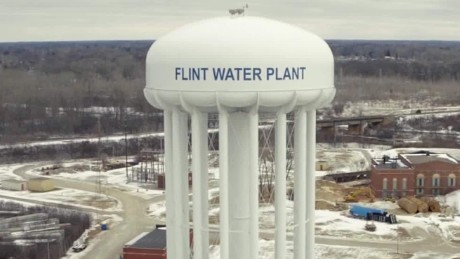
Nonetheless, we might have reached a turning point. A North American geography of water abundance—one in which Utah textbook writers could picture make-believe Lake Michigan whales—now includes its own all-too-real, fully imaginable site of empathetic horror: the water crisis in Flint, Michigan. A conspiracy of negligence that lead-poisoned an entire population became, if possible, more terrible because Flint residents once had, were recklessly deprived of, and yet remained painfully close to abundant safe water.[5] Flint has generated a new emotional Great Lakes geography that transcends politics, occupation, class, and colour. How easy to imagine in a Flint home whose water tap holds invisible terrors and irreversible harm for your family. On this mental map, the home is only inches from Lake Huron, the fourth largest freshwater lake on Earth.[6]
We propose scarcity and abundance as the two faces of U.S. and Canadian water history. Alongside scarcity, abundance has been a different but powerful driver of water law, policy, economics, and culture in both countries. We would encourage water scholars to shout across the great arid-humid divide of the 100th meridian whenever possible, or even to “[erase] the 100th meridian as a scholarly demarcation,” as historian Donald Pisani advocated.[7] To the famous 100th meridian we add the less-examined 49th parallel between Canada and the United States as an important locus for a more unified water studies. North America’s largest waterway (the Great Lakes–St. Lawrence system) makes up such a long stretch of this border that water history in either country would be incomplete without it.[8] But the 49th parallel has importance beyond the Great Lakes. Whether scarce or seemingly abundant, whether west, mid-continent, or east, relationships between communities and water play out differently on the border and create their own spillovers to the north and south – as the various contributors to Border Flows demonstrate (see map below).

References
[1] Lynne Heasley, “Paradigms and Paradoxes of Abundance: The St. Lawrence River and the Great Lakes Basin” (paper presented at the First World Congress of Environmental History, Copenhagen, August 2009). Heasley’s current book project—“The Paradox of Abundance: Essays on the Great Lakes”—grew out of this paper.
[2] The foundational work of North American water history on which historians and theorists continue to build and elaborate is Donald Worster’s Rivers of Empire: Water, Aridity, and the Growth of the American West (1985; repr. New York: Oxford University Press, 1992). For a contemporary theoretical overview of the social production of water scarcity and abundance in service to a modern hydraulic society, see Andrew Biro, “River-Adaptiveness in a Globalized World,” in Thinking with Water, ed. Cecilia Chen, Janine MacLeod, and Astride Neimanis (Montreal: McGill-Queen’s University Press, 2013), 166–84.
[3] Alicia Acuna and David Burke, “Colorado to California: Hands Off Our Water,” Fox News Politics, January 28, 2015; Marianne Goodland, “Rainbarrel Bill Dead for Session,” Colorado Statesman, May 4, 2015; A recent stunning example is Matt Black’s portfolio in “The Dry Land,” The New Yorker, September 29, 2014, http://www.newyorker.com/project/portfolio/dry-land.
[4] Jerry Dennis, The Windward Shore: A Winter on the Great Lakes (Ann Arbor: University of Michigan Press, 2012), 11–12.
[5] Flint Water Advisory Task Force, Final Report, commissioned by the Office of Governor Rick Snyder, State of Michigan, March 21, 2016.
[6] Or the fourth largest, depending on whether you include the Caspian Sea.
[7] Donald J. Pisani, “Beyond the Hundredth Meridian: Nationalizing the History of Water in the United States,” Environmental History 5, no. 4 (2000): 476.
[8] In the past decade, an important literature has emerged to rethink and theorize North American borderlands, with an emphasis on transnational and comparative history. See Benjamin Johnson and Andrew Graybill, eds., Bridging National Borders in North America: Transnational and Comparative Histories (Durham: Duke University Press, 2010); Michael Behiels and Reginald Stuart, eds., Transnationalism: Canada–United States History into the Twenty-First Century (Montreal: McGill-Queen’s University Press, 2010); Matthew Evenden and Graeme Wynn, “Fifty-Four, Forty, or Fight? Writing within and across Boundaries in North American Environmental History,” in Nature’s End: History and the Environment, ed. Sverker Sörlin and Paul Warde (New York: Palgrave Macmillan, 2009); and Victor Konrad and Heather Nicol, Beyond Walls: Re-inventing the Canada–United States Borderlands (New York: Ashgate, 2008). The scholarship also examines regionality at the border: Sterling Evans, The Borderlands of the American and Canadian Wests: Essays on Regional History of the Forty-Ninth Parallel (Lincoln: University of Nebraska Press, 2006); Kyle Conway and Timothy Pasch, eds., Beyond the Border: Tensions Across the 49th Parallel in the Great Plains and Prairies (Montreal: McGill-Queen’s University Press, 2013); John J. Bukowczyk et al., Permeable Border: The Great Lakes Basin as Transnational Region, 1650–1990 (Pittsburgh: University of Pittsburgh Press, 2005); Ken Coates and John Findlay, eds., Parallel Destinies: Canadian-American Relations West of the Rockies (Seattle: University of Washington Press, 2002).
Latest posts by Daniel Macfarlane (see all)
- Hydro Power, Energy Transitions, and the Onset of Canada’s Great Acceleration - May 13, 2026
- Special Issue – US–Canada Energy and Environmental Relations - April 29, 2026
- Canadian Environmental History at ASEH 2026 - March 23, 2026
- Finding Environmental History in “The Wreck of the Edmund Fitzgerald” - November 7, 2025
- The Erie Canal at 200 - October 26, 2025
- Canadian Environmental History at ASEH 2025 - April 8, 2025
- Podcast Episode – Who (Really) Owns the Great Lakes? - March 3, 2025
- Collaboration, Community, and Careers: Reflecting on NiCHE at 20 - November 8, 2024
- New Book – The Lives of Lake Ontario: An Environmental History - September 5, 2024
- Call for Papers – ARCS Special issue on Canada – U.S. Environmental Relations - June 17, 2024
1 Comment